The USDA-NRCS National Cooperative Soil Survey (NCSS) Web Soil Survey is a free, powerful online tool that allows us to draw a polygon around an area on a map and obtain valuable information about the location’s soils.
Soil scientists have field investigated and thoroughly mapped and described Indiana soils. The web soil survey has a ton of information. It can even tell you if the soil is suitable for a basement. There is a wealth of information on soil types and poperties that are helpful for agriculture. A poorly-drained soil indicates that a grower might be dealing with wet soils in the spring. There are also notations for “prime farmland’, though the smaller scale of urban agriculture often allows us to add organic matter and build soil health to create productive growing mediums almost anywhere.
To access the web soil survey, use this link. Check out the help button for an overview on how to use the tool, but don’t hesitate to reach out to the SWCD for assistance.
https://websoilsurvey.sc.egov.usda.gov/App/WebSoilSurvey.aspx
Before these maps were accessible online, the USDA-NRCS printed a soil survey booklet for each county. The online tool makes it easier to find a location on map and produce information, but the “old” soil surveys also have a lot to offer. Here are the quick links to the scanned pdfs for Marion and Hamilton counties.
State by State
https://www.nrcs.usda.gov/conservation-basics/natural-resource-concerns/soil/soil-surveys-by-state
Marion County
https://nrcs.app.box.com/s/p1x6w5v2grgrg8zx7xizglwog2jp6taz/file/982813126347
Hamilton County
https://nrcs.app.box.com/s/p1x6w5v2grgrg8zx7xizglwog2jp6taz/file/982809743312
These old soil surveys give detailed descriptions of each soil type and contain interesting information on the factors of soil formation in our county. Soil formation is dependent upon:
1. The physical and mineralogical composition for the parent material
2. The climate
3. The plant and animals life on and in the soil
4. The relief or lay of the land
5. The length of time the forces of soil formation have acted on the soil material
Here is an excerpt from the Marion County soil survey on “parent material”:
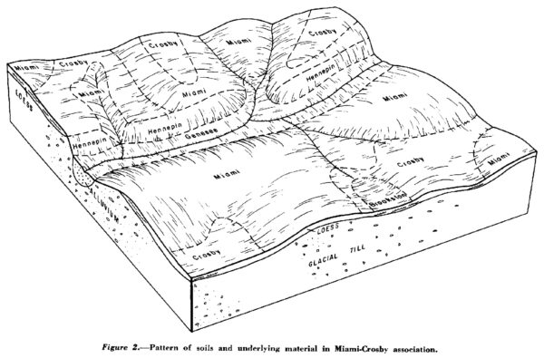
“The parent material of the soil of Marion County was deposited by glaciers or by melt water from the glaciers that covered the county from about 20,000 to 25,000 years ago. Some of this material was reworked and redeposited by the subsequent action of water and wind… The dominant parent material in Marion County is glacial till, glacial outwash, and alluvium.
Glacial till is a material laid down directly by glaciers with a minimum of water action. It consists of particles of different sizes that are mixed together. Some small pebbles and even some boulders in glacial till originated from bedrock hundreds of miles from Marion County. The glacial till in Marion County is calcareous and firm. Its texture is loam. Miami soils are examples of soils formed in glacial till. These soils typically are medium textured and have well developed structure…
Alluvial material was deposited by floodwater of present streams in recent time. This material varies in texture, depending on the speed of the water from which it was deposited. The alluvium deposited along a swift stream, such as the White River, is therefore coarser textured than that deposited along a slow, sluggish stream, such as Little Buck Creek.”
The history of soil formation is fascinating, but it also has implications on the way we farm in Indianapolis. The “calcareous” nature of the soil means we have a high pH, both in our soils and in our water supply. We often seen pH of garden soils at 7.5 or more, so amending the soil with products like sulfur might be beneficial to reach a more neutral pH of 7, which is better for growing most crops. The soil survey tells us that subsoil at 4’ deep at that location has an organic matter rating of 0% and a pH of close to 8. Not great for growing anything! So we need to be careful about using fill from subsoil or dug out basements for gardens. If you do find yourself with subsoil, compost and conservation practices can start regenerating the soil. Its important to remember that TIME is also one of the 5 factors in soil formation. However, with our smaller scales and knowledge on how to improve soil health, the old saying that “it takes 100 years to create an inch of topsoil” is gathering more dust than a 1908 soil survey.
Here’s a drawing of the common Miami-Crosby soil association from the Marion County soil survey: